
Part 1 of 4 in a series, "Our changing cities."
Cows used to trot past Tina Ott's Woodbury backyard, on their way to and from pasture.
Then the neighboring Schilling farm was sold, transformed into a shopping area, senior apartments and the Harvest Commons housing development. Now she can see a Jerry's Foods grocery store from her back window — and she's OK with that.
"It's progress," said Ott, a Realtor. "I just happen to be near it."
Cropland gives way to cul-de-sacs. Warehouses and factories become clusters of condos and commerce. Buildings are cleared for redevelopment.
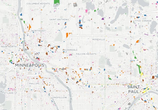
New land use data, collected by the Metropolitan Council and analyzed by the Star Tribune, provides the first look at how the Twin Cities metro area has changed since the recession.
Measured by sheer acres of change, suburban Woodbury, Lakeville and Maple Grove, plus the central cities of Minneapolis and St. Paul, led the way.
It's a combination of development reshaping landscapes on the metro's edge, carving up farms into housing, and reuse of industrial properties in the central cities, such as the closure and demolition of St. Paul's Ford plant.
"Cities in their peak development years are doing lots of land-use changes as they're developing really for the first time," said Libby Starling, the Met Council's deputy director of community development. In Minneapolis and St. Paul, she said, "Because the development patterns in those cities are so old, there's a lot of opportunity for repurposing land uses that have outlived their original uses."
The Met Council takes aerial photos of the seven-county metro area every five to seven years to determine how every inch of land is being used, aided by property assessment records. It isn't perfect — the analysis relies on human judgment, sometimes correcting past imperfections — but cities across the region use the detailed maps and data to plan for the future. The Star Tribune compared the Met Council's 2016 survey with its last flyover in 2010.
The broader trends, like swaths of suburban change, are clear. Altogether, Woodbury, Maple Grove and Lakeville have lost 2,500 acres of undeveloped or agricultural land since 2010.
Woodbury Community Development Director Dwight Picha said two of that city's larger housing additions, Dancing Waters and Stonemill Farms, were the final pieces of projects approved long ago.
"They took 10 to 15 years to develop," Picha said.
Aside from housing, other big changes included the demolition of the 100-acre State Farm campus off Radio Drive in Woodbury. The new Hwy. 610 freeway gobbled up about 100 acres of undeveloped land in Maple Grove. Steps from Interstate 35W in Lakeville, a mine has closed and a new Walmart Supercenter has sprung up across the street.
Arden Hills also stood out in the metro area for the amount of change it's seeing relative to its size. About 18 percent of the city's land shifted uses with the clearing of the Twin Cities Army Ammunition Plant, which is now primed for development.
In Minneapolis and St. Paul, the biggest change was the loss of industrial land. The cities have about 600 acres less of it than they did in 2010. That was partly due to the decommissioning and demolition of the Ford Plant. But a lot of industrial property also became commercial, housing or mixed use.
St. Paul saw a vacant warehouse razed to make way for CHS Field, and the former 3M headquarters was demolished. The former Hamm's brewery complex now has a mix of occupants: a trapeze business, a taproom brewery and an aquaponics operation.
In Minneapolis, a riverfront flour mill and North Loop warehouses have been converted to housing, along with the demolition of buildings housing Scherer Bros. Lumber, Superior Plating and Shapco Printing. From the sky, however, few areas changed as dramatically as those surrounding the Midtown Greenway in Uptown, where apartment buildings have sprung up rapidly since 2010.
JoAnna Hicks, a principal at Element Commercial Real Estate, said it's tough now to find a large industrial property in Minneapolis "at an industrial price."
"Everybody wants to convert them into creative office or some other sort of higher and best use," Hicks said.
We'd like to hear about what's happening in your neighborhood. Use our interactive map to look at land use changes in your area. Then share what you found in the comments below or on Facebook, Twitter or other social media platforms. Copy the URL from the map (while zoomed to your location) and paste it with your comments, as well.


