


Baptism on the trail
Hiking in hypothermic conditions from the start wasn’t the vision.
Fat drops of rain pelted the windshield. The wipers dutifully swept back and forth in graceful arcs, but they couldn't stay on top of the torrent. I glanced at the temperature on the dashboard, even though I knew what it said: 45 degrees.
Ed, my husband, and I turned and looked at one another, expressionless. Sighing, I pushed open the door and stepped into the maelstrom. "This is going to be a lot of fun," Ed said.
Hiking 16-plus miles in hypothermic conditions was not how I envisioned my first day (June 2) on the Superior Hiking Trail. Most hikers would likely opt to begin another time. But I'd been duped. My weather app said rain would move in during the afternoon, not greet us in the parking lot before we'd even placed a boot on the trail. So here we were, sitting at the trail's southern terminus, backpacks loaded. We might as well give it a go.
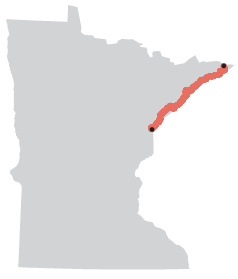
The Superior Hiking Trail takes its name from the massive body of water nearby, and with good reason — because the trail is all about this greatest of Great Lakes. Beginning in 1986, the trail's founders set out to build a long-distance path patterned after the Appalachian Trail. Like the Appalachian Trail, this one would also run along a rocky ridge. But in this part of the country, it would be the ridge framing the North Shore and Lake Superior. As it unspooled northbound, the path would cross dozens of creeks, rivers and waterfalls, all of which form the Lake Superior watershed. And it would tease and treat hikers by offering occasional eye-popping views of the lake. Getting a little waterlogged while hiking this path, then, would be my baptism into its ranks.
Brian Peterson, Star Tribune
I was heartened because I was starting out on this arduous, 310-plus-mile thru-hike with my husband. His presence would be the boost I needed on such a grim day. But I was worried, too. I was decked out in several layers of rain gear — I even had an umbrella — while he was clad in a simple rain jacket and shorts. No rain pants, no gloves, no poncho. "My legs never get cold," he said, when I fretted about his meager attire. So we ducked into the woods around 9:30 a.m., hoping for the best.
The Superior Hiking Trail actually has two southern terminuses. The super-official one is the terminus I selected: a spot hidden deep in the forest on the Minnesota-Wisconsin border, just southeast of Jay Cooke State Park. (The other terminus, 51 miles away in Duluth, is favored by backpackers, as there are 94 official Superior Hiking Trail campsites from that point on.) To reach the super-official terminus, marked by a small sign, you must hike in 1.9 miles from the Wild Valley Road parking lot and then turn around, hike back out and continue on your way.
As we began tromping toward the terminus, thick stands of aspen and maple arched their branches protectively overhead, diverting much of the water from our bodies. Songbirds chirruped merrily, despite the gloom, while a profusion of trillium nodded their white heads in greeting. This might not be so bad after all.
But a few hours later, after completing the out-and-back to the southern terminus and then following the path into the heart of the state park, things began to unravel. Angry clouds muscled their way across the sky, dismissing the light rain and replacing it with thick sheets of water. Within minutes we were drenched. Then, as puddles mushroomed into small lakes, even our shoes filled with water. Pulling our rain gear more tightly against our chilled bodies, we trudged along, heads down.
It was midafternoon when we reached Jay Cooke's famous swinging bridge, which offers postcard views of the St. Louis River tumbling across jagged, black rocks en route to its rendezvous with Lake Superior. Children clad in colorful rain ponchos raced along the span, checking out the various viewpoints, their ponchos billowing like balloons. Ed and I barely had enough strength to glance up.
When we arrived at our motel several hours later, Ed was shaking uncontrollably. I tucked him into a steaming shower and whispered promises of a better hike tomorrow.
Conditions did improve the following day. Although the skies were opaque as we labored up to the summit of 1,219-foot Ely's Peak, obscuring what should have been an incredible view, the temperature had warmed and the rain stayed at bay. Still, I was dismayed at the vast stretches of trail that had devolved into thick muck or were covered by inches of water, courtesy of the rain and spring snowmelt. The trail's elevation chart already sported an unending series of jagged spikes; add treacherous footing to the mix, and you've got one heck of a challenge. Perhaps I'd made a colossal error in tackling the Superior Hiking Trail, at least at this time of the year.
And then, on Day 3, we entered Enger Park. With the sun finally high in the sky, we segued onto a side trail leading to an observation tower. Despite the cruelty of having to climb 92 steps after all of the ascents I'd asked of my legs these first days, the view at the top silenced all of the negative chatter in my head. Stretched before me was Lake Superior in all of its glory.
Heading out of Duluth the following morning, the trail climbed northeast, away from the lakeshore. As I splashed through puddles and slipped in the mud, I focused on the clusters of delicate bluebells and red columbine brightening my passage; on the smiling blue fish fastened to a tree at Del's Pond; on the bleached animal bone set on top of the sign marking the French River. And I gave thanks that, four days in, my hamstring was feeling strong and my body remained tick-free.
Melanie Radzicki McManus is a freelance writer. Her book "Thousand-Miler" chronicles her thru-hike of Wisconsin's Ice Age National Scenic Trail. She lives near Madison, Wis.