
The greatest river in North America begins in Minnesota. But our pristine stretch of the Mississippi faces mounting environmental threats.
Minnesota's Threatened Rivers
Story by Josephine Marcotty • Photo and video by Aaron Lavinsky • Star TribuneSunday, October 2, 2016
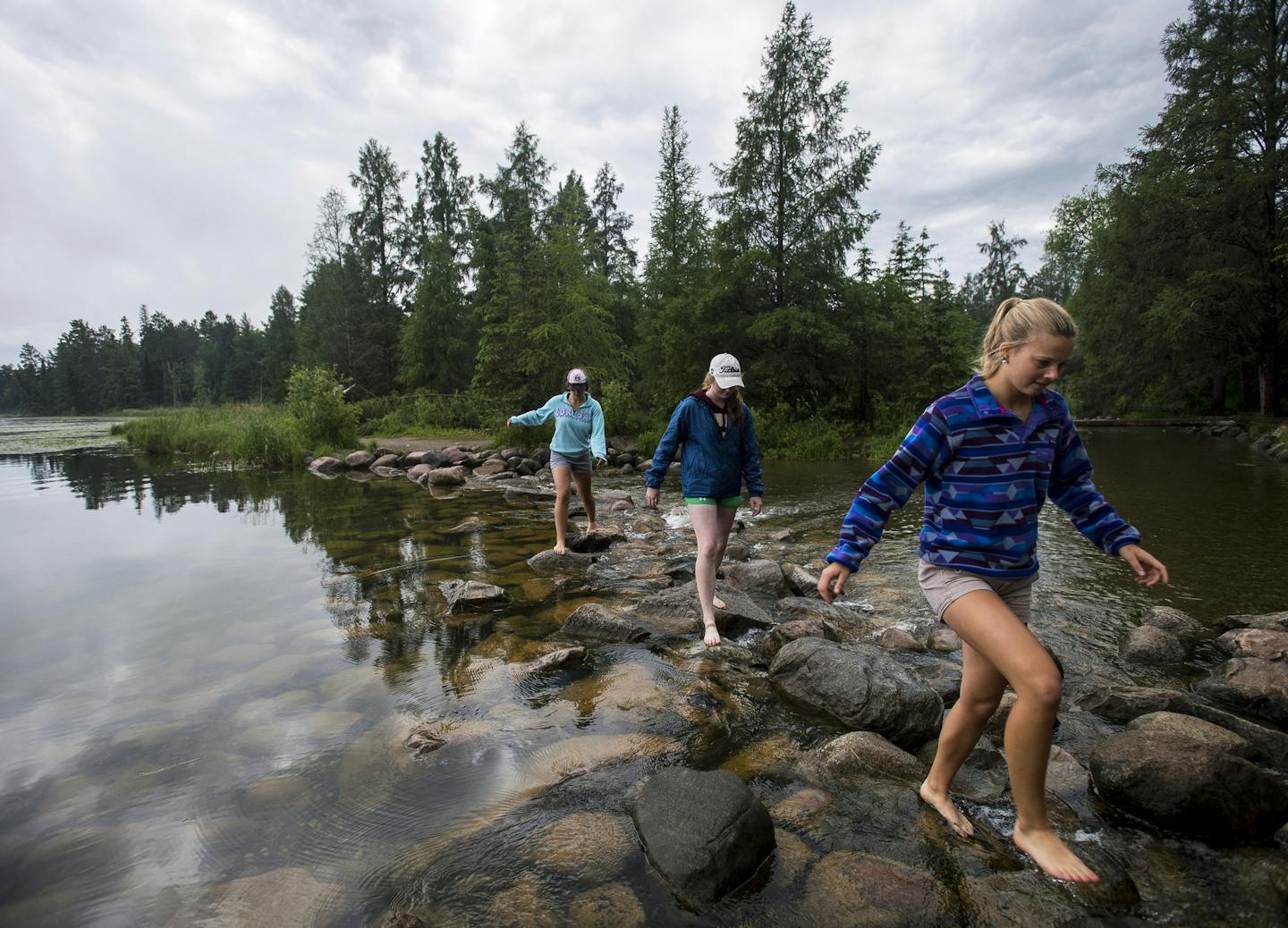
PARK RAPIDS, MINN. – The mating dance of the hex mayflies drew John Sorenson to the Straight River at sunset.
As the bugs floated like snowflakes in the fading summer light, he pulled on his waders and waited patiently for the distinct sound of trout breaking the dark water to feed.
"It's a treasure," he said, stepping to the edge of the grassy bank and casting his line, as he has for years.
But the Straight River is becoming warmer and more polluted as farm irrigation rigs multiply along its banks. Now Sorenson fears that the fish huddling in the cooler deep spots are a stark sign that northern Minnesota's only naturally producing trout stream is in trouble.
"In 10 years the Straight River could be a big muddy stream good only for carp," he said.
And the peril is flowing downstream — into the Mississippi River and across a watershed that covers almost half of Minnesota, signaling a new and rising threat to one of the state's great natural wonders. Like many others across Minnesota, the great river is heading toward an ecological precipice.
In the last five years, the Upper Mississippi watershed has lost about 400 square miles of forests, marshes and grasslands — natural features that cleanse and refresh its water — to agriculture and urban development. That's an area bigger than Voyageurs National Park and represents the second fastest rate of land conversion in the country, according to one national study.
That breathtaking transformation is now endangering the cleanest stretch of America's greatest river with farm chemicals, depleted groundwater and urban runoff. At this rate, conservationists warn, the Upper Mississippi — a recreational jewel and the source of drinking water for millions of Minnesotans — could become just another polluted river.
Here, around Park Rapids, potato fields are replacing forests, and drinking wells show rising levels of nitrate contamination from fertilizers.
Along the western edge of the vast watershed, soaring demand for irrigation is depleting sensitive aquifers and rivers that feed the Mississippi.


A

GREAT RESPONSIBILITY: John Sorenson, top, fished the Straight River, a trout stream in the Mississippi watershed that is becoming more polluted. Minnesota has an outsized responsibility for the Mississippi, which starts in Itasca State Park, above. But it is facing battles over land use and water quality that taps into deeply held values "like clear lakes, stewardship," said scientist Bonnie Keeler.And where the Upper Mississippi curves like a giant question mark through the center of Minnesota, many of its tributaries are showing signs of stress — phosphorus that breeds algae, sediment that makes the water cloudy, even bacteria in stretches farther downstream.
"What we do to our land, we do to our water," said John Linc Stine, commissioner of the Minnesota Pollution Control Agency. Yet because most land use decisions are in the hands of private property owners and local governments, Minnesota has limited power to protect the river. "We can see it coming and still not be able to do something about it," Stine said.
The battles over land use along the great sweep of brown river go beyond drinking water, to deeply held values that give the headwaters state part of its identity, said Bonnie Keeler, an environmental scientist at the University of Minnesota.
"Like clear lakes, stewardship, a sense of place and pride, and the identity of Minnesotans around clean water," she said.
Quite beyond their sheer beauty, forested lands in the watershed also provide immense economic value in purifying drinking water for millions of people, an issue that has drawn the attention of federal regulators. This past summer, the U.S. Environmental Protection Agency launched a special project to predict how changing land use around the Upper Mississippi affects water quality, part of a larger effort to understand the threats facing major drinking water systems across the country.
Keeler, who directs the Natural Capital Project at the university and studies the social value of such things as clean water and forests, said it's hard to find the right balance between protecting the Upper Mississippi and preserving economic engines such as agriculture and tourism. But, she added, the debate has thrust a new kind of environmental thinking to the forefront: Clean water, natural landscapes and wilderness have an economic value that deserves a place in the broader equation that defines a healthy economy.
In short, Keeler said, "What would a map of an ideal watershed look like?"
Running out of time
Conservation groups in Minnesota aren't waiting for the answer. Working with state agencies, they are scoping out the most ecologically valuable tracts of land and water in the Upper Mississippi's 20,000-square-mile watershed. Using public and private funds, they're buying key parcels outright or protecting them with permanent easements that prevent development.
The project has become a priority in deploying money from Minnesota's 2008 Legacy Amendment, the landmark sales tax increase for culture and nature. So far, Legacy funds have helped protect about 250 square miles in the Upper Mississippi watershed, with more in the works.
And the Nature Conservancy, which studied land use in the watershed to produce those startling numbers on lost forests and wetlands, has created a $10 million fund to protect key parts of four primary tributaries — the Crow Wing, the Pine, the Sauk and the Rum.
While they meet regularly to discuss new threats and opportunities in the watershed, conservationists and state environmental officials agree that Minnesota has no one in charge and no master plan to rescue the river. That leaves critical questions unanswered: How much land must be protected to preserve the natural infrastructure around the Upper Mississippi? Will local opposition place crucial parcels out of reach?
And they wonder whether Minnesota can move fast enough.
In other parts of the country, communities have discovered the cost of waiting too long. In 2014, the city of Toledo warned residents not to drink their tap water after pollution from farms and sewage treatment plants created toxic algae blooms in Lake Erie. Last year, the city of Des Moines took the extraordinary step of filing suit against upstream drainage district managers for allowing high concentrations of nitrates from farmland to flow into the city's drinking water.
Other states have had more foresight. Around the Quabbin Reservoir that supplies much of Boston's water, for example, Massachusetts placed protections on 182 square miles and allows only extremely limited hiking, biking and boating — and no swimming. Though state officials denied it, a recent plan to reintroduce an endangered timber rattlesnake to the area was seen by some as an indirect way to deter visitors.
"We know what happened where we lost [clean-water] infrastructure — and the cost of getting it back," said Richard Biske of the Nature Conservancy. "It's either pay a little bit now or a lot later."
Contaminated wells
One of the key battlegrounds in protecting the Upper Mississippi will be the Pineland Sands Aquifer, a 770-square-mile water formation that lies beneath the Straight River and the central-Minnesota town of Park Rapids.
In 2014, Fargo-based R.D. Offutt, the nation's largest potato grower, stunned state regulators by applying for a whopping 54 irrigation permits, each of which would allow Offutt to pump as much as 1 million gallons of water per year from the aquifer.

O
futt's plan represented just the latest in a burst of demand for agricultural irrigation in an area known for sandy soils that can become perfect for growing corn, soybeans and potatoes — given sufficient water. Irrigation has increased by an average of 77 million gallons per year since 1988, or 85 percent, according to the Minnesota Department of Natural Resources (DNR).
Nitrate contamination of local drinking water has climbed in lockstep. The city of Park Rapids had to dig deeper wells at a cost of $3 million, and in some areas above the aquifer more than 10 percent of private drinking wells have nitrate concentrations above the level considered safe for infants and pregnant women.
Excess nitrates, bacteria and sediment have also turned up in the nearby Crow Wing River, which provides one-fifth of the water volume in the Mississippi after they merge near Brainerd.
"This is the headwaters of the Mississippi," said Randy Wenthold, who lives near Park Rapids. "If we are polluting this area, it's floating downstream … to the people of the Twin Cities. It's coming at you, baby. Whether you like it or not."
For decades, much of the aquifer was covered — and protected — by forests managed by the Potlach Corp., once the largest private land holder in Minnesota. But now Potlach is moving most of its tree-growing operations elsewhere. Above the sensitive Pineland Sands Aquifer, about 10,000 acres have been or soon will be deforested for farming, and another 20,000 could be, DNR officials said.
The expansion of agriculture has slowed for now, in part because of a drop in corn prices. Ironically, Offutt embarked on the expansion of its potato fields in large part to reduce pollution to local drinking water. Adding more fields meant it could rotate potatoes more often with other crops that require fewer chemicals. Last year it reduced its request for permits to five, and the DNR and other state agencies are trying to gauge the scope of the problem.
The Minnesota Department of Agriculture is studying how nitrates move from soil to groundwater in land that's never been cultivated. And the DNR is planning a $1.5 million project to study the movement of water to and through the aquifer — and just how much irrigation it can tolerate.
Sorenson, the Straight River trout angler, said he's glad the state is stepping in. Even so, he worries about the rising demand for water and the next big drought. What will happen to the trout, he wondered, if all the groundwater goes to corn and potatoes?
"If it was for national defense, if it was for hungry people, I'd be all for that," he said. "But for French fries for an already overweight country? That triggers my ire."

I

addition to studying the aquifer, state agencies and conservation groups are taking advantage of the lull in land conversion to acquire prime pieces of the Potlatch properties.
But that can go only so far, said Richard Peterson, who manages a forest easement program for the DNR. Peterson estimates that the state will be able to protect only 10 percent of the forested land over the Pineland Sands aquifer. A key reason: local governments object when easements or public ownership halt the progress of private development and reduce local tax revenue.
"We are putting this price on conservation," said Matthew Hilgart, policy analyst for the Association of Minnesota Counties. "But at the cost of what? Property tax increases? Service reductions? Is that fair to the local population?"
Hilgart says the Legacy Amendment, though well intentioned, has spawned local animosity toward state government and conservation groups. Half of Itasca County, for example, is now in public hands, he noted.
"We have not reached this huge anti-government … atmosphere. But I don't want us to," he said.
Paving paradise
North of Brainerd, where the Mississippi starts to curl south, there's another kind of deforestation underway. But this one — exemplified by the tree stumps alongside the new four-lane Highway 371 — is driven by the growing number of people seeking the quintessential Minnesota getaway.
The population around Minnesota's lake country is growing rapidly, and is expected to accelerate as baby boomers retire. The population of Crow Wing County has risen 15 percent since 2000 — faster than the state as a whole — and is projected to rise another 13 percent in the next two decades. And that doesn't include the seasonal vacationers who clog the roads every summer weekend, driving the expansion of Highway 371.
"This is just a darn nice place to live," said Rod Osterloh, who's been working as a real estate agent in the Brainerd area for 30 years. "There's high quality water, fishing, hunting, lots of recreation and proximity to the Twin Cities." As a result, he added, "There's traffic all the time."
At the same time, grandparents are dividing their lake home properties to help pay taxes or hand them down to their kids and grandkids, said Jeff Forester, executive director of the Minnesota Lakes & Rivers Advocates. "It's the largest intergenerational transfer of forested land in history," he said. "And you can't put it back together."
Taken together, these trends mean more roofs, lawns, docks, driveways and boats — all of which can drive water pollution.
Starting a few years ago, Crow Wing County began requiring stormwater management systems for any property that has 15 percent or more hard surfaces. That's the point where "you start seeing problems" in water quality, said county land manager Chris Pence.
But local governments are already facing hard choices.
This year the Crow Wing County Board of Commissioners created a tempest when it voted overwhelmingly to allow ATV and snowmobile trails in a protected forest it owns along the Mississippi near the Brainerd airport.
The land, once slated for development, was purchased from Potlatch with $11 million in Legacy funds as a major forest conservation area. But motorized trails are not good for wildlife or habitat, said outraged members of the state's Lessard-Sams Outdoor Heritage Council, a body that advises the Legislature on the use of Legacy funds. Giving it to ATVs and snowmobiles, they said, violated the spirit of the Legacy Amendment.
Crow Wing County Administrator Tim Houle says the county was always clear in its intentions. But the larger problem, he said, is that other counties saw Crow Wing take a lashing and are now wary of conservation partnerships with the state.
"We have been mistreated by the Lessard-Sams folks," he said.
'God awful insult'
One day this past summer, some of the farmers around Rice, Minn., left their fields to attend a meeting in town with state pollution officials. For two hours they listened to experts from the DNR, the Agriculture Department and the Health Department explain the hydrology of aquifers and the risk of high nitrates in drinking water.
"A baby can drink three bottles of it and die," said Rich Soule, a hydrologist with the Health Department. "We lose sleep about it."
The farmers were hearing quite a different message: That their way of life was at risk. Collectively, they have invested millions of dollars in the chemicals and massive irrigation systems that, over the last few decades, have transformed the sandy soils of Benton and Morrison Counties near St. Cloud into an extraordinarily rich region for corn, soybeans and potatoes.
Water from the aquifer, in short, is what built their lives, their families and their community.


TR

NSFORMING THE LAND: Farmers have invested millions of dollars in irrigation systems, transforming the land but also raising conflicts over water. To farmer Wally Parkins, right, that's just the way it has to be. "We are big drivers of the local economy."Now these government officials were suggesting that the state might restrict their use of water — all to protect a modest stream called Little Rock Creek that carries a rising load of agricultural pollution into the powerful sweep of the Mississippi River flowing serenely past them just 2 miles away.
"It's a god awful insult on us," said farmer Dean Zimmerman.
Conflicts like this one are intensifying up and down the lower part of the river's watershed, between Little Falls and St. Cloud. Here the forests give way to farms and cities, and most of the tributaries that flow to the Mississippi are in trouble.
To Wally Parkins, that's just the way it's got to be, as long as people need food and a place to live. Parkins, who raises corn, soybeans and potatoes, farms 5,300 irrigated acres around Royalton, north of St. Cloud.
"That's more important than a little disruption to the planet," he said.
Driving his pickup truck past iridescent green rows of corn in midsummer, Parkins pointed to the massive irrigation pivots that arched over his fields. Each one assures that the soil will produce the perfect oblong potatoes that consumers expect. He sells his crop to Michael Foods, a Minnetonka company that turns them into French fries and hash browns under the brand Simply Potatoes.
Farming, he said, paid for the recent county school referendum. Without it, he said, "kids, schools, everything would shrink dramatically in rural areas. We are big drivers of the local economy."
But irrigation around Little Rock Creek has increased 180 percent in the last 25 years, and shows no sign of slowing down, according to DNR officials. Nitrate levels are rising in the Rice community drinking water system and in private wells.
Ken Nodo has lived next to Little Rock Creek all his life, and he used to fish for trout there as a boy. He pointed out a deep wide spot where he could once see straight down to the sandy bottom.
"This was my little hole," he said. "But it's all mud."
Nodo doesn't blame local farmers for fighting to hang onto their investments and their way of life. "Naturally they are upset," he said, because their days of unlimited water use are probably over.
It's just too bad, he said, that the state didn't step in 25 years ago — before it was too late for Little Rock Creek.
Part 2: The Red RiverPolluted River's Toll
The Red River winds through a sweeping landscape of farms, carrying chemicals downriver that are poisoning Lake Winnipeg – a fate that Minnesota's other rivers could face.
GRAND BEACH, MANITOBA – On the last glorious Sunday in August, lifeguard Maddi Danyluk walked down the most famous beach in Manitoba as the sun set fire to a bank of clouds right where the blue lake merged with the western sky.
Danyluk had one eye on the kids still romping in the water, but the other was on the turquoise stains that streaked the golden sand.
"There's tons of it," she said, wrinkling her nose at the blue-green algae lining the beach and floating like a dense mat of grass clippings in the shallows. "It just stinks."
It also threatens to kill Lake Winnipeg, proudly known as the sixth Great Lake among the Canadians who flock to its famous beaches and fish its waters for walleye. In just two decades, pollution in the lake has doubled, with most of it coming from the Red River that runs north through the rich agricultural lands of Minnesota, the Dakotas and Manitoba.
The deterioration of Lake Winnipeg is a stark example of what Minnesota faces as its rivers are increasingly contaminated by a transformation of the land around them: The price flows inevitably downstream, and it's excruciatingly difficult to fix.
Visitors to Lake Winnipeg find that their treasured short summers are marked by increasing numbers of sometimes toxic algae blooms, which chase swimmers away from the beaches and foul the nets of fishing families that have made their living here for generations. Temporary dead zones — water devoid of aquatic life — are starting to appear in the lake's vast northern basin, a sign that the lake may soon reach a tipping point.


STA

K SIGNS: Visitors to Lake Winnipeg, such as brothers Trace, 11, and Isaiah Wiens, 6, of Steinbach, Manitoba, are finding increasing numbers of sometimes toxic algae blooms, above, stark evidence of growing pollution.While the Red River provides only 15 percent of the water in Lake Winnipeg, it carries almost 50 percent of the phosphorus that is creating the algae, mostly from the vast farmlands in Minnesota and North Dakota.
Now, after years of research and gentle pressure from Canadian governments, the United States and Minnesota have signed on to a simple plan called the Lake Friendly Accord: Cut phosphorus pollution from farms, cities and water treatment plants by 50 percent.
But in recent decades the Red River has become a massive storm sewer. Pollution at the Canadian border has been rising since 1994 and there's little consensus in how to stop it. "We are going downhill," said Jeff Lewis, executive director of the Fargo-based Red River Basin Commission, a cross-border organization charged with finding a solution.
The slow progress creates a sense of despair among the Winnipeggers who spend their summers in the cottage communities that ring the southern part of the lake. "It's a very helpless feeling," said Nancy Hodgson, who raised her children and now her grandchildren in the storybook village of Victoria Beach.
Property values have dropped, said her husband, Brian Hodgson, the reeve — or mayor — of the town, who fears the losses may reflect Lake Winnipeg's growing reputation for pollution and algae blooms. Now kids are starting to cut their feet on the razor-sharp zebra mussel shells that litter the beaches — another gift from the Red River.
"I guess we have you Americans to thank for that, too," he said, teasing gently.
Dramatic changes
The Red River of the North starts in Breckenridge, Minn., at the confluence of the Otter Tail and Bois de Sioux rivers. From there, it forms the border between Minnesota and the Dakotas as it follows the path of a glacier that receded north 10,000 years ago. It zigzags for 500 miles through what was once a vast prairie region of grass and wetlands before opening up into Lake Winnipeg.
The prairies are long gone, plowed and ditched to create some of the richest farmland in the world. But in recent decades, agriculture has changed dramatically. Gone are most of the pastures, oats, sunflowers and wheat. In the western part of Minnesota, those crops have been replaced with chemically intensive corn, soybeans, sugar beets and potatoes, which now grow horizon to horizon all the way to the Canadian border.
Along with the crops came more drainage — tens of thousands of miles of perforated plastic tubing laid in the soil below corn and other row crops to move water off the land even faster. That coincided with major increases in precipitation starting in the early 1990s that have increased the 10-year average flow in the Red River by 50 to 60 percent.
For most Minnesotans, the Red River's biggest problem is seasonal flooding that wipes out crops, inundates their towns and inspired the bitterly contested $3 billion Red River diversion project around Fargo, N.D.
Far less noticeable is that the Red River is sending increasing amounts of phosphorus, nitrates and sediment from Minnesota and the Dakotas north to Lake Winnipeg.
"It's like a big gun barrel," Robert Kristjanson, who along with his sons and daughters runs a commercial fishing business out of Gimli on the southwest side of Lake Winnipeg. "And we are on the other end."
Kristjanson's grandchildren are the sixth generation of Icelandic fisherman who first came to Gimli in the later 1800s. Today about 1,000 commercial fishers still live much the same way. They spend weeks out on the lake in their boats and camped out on islands, filling their holds with whitefish, walleye — or pickerel, as they say — and goldeye for commercial markets around the world. In winter they stretch nets beneath the ice and haul fish to shore with Bombardiers, competing with the thousands of Minnsotans who come north for ice fishing there.
Lake Winnipeg, said his son Chris Kristjanson, is not like the cold, pristine Lake Superior — it's teeming with fish and aquatic life. In fact, for now, he said, phosphorus may be making the lake even more productive by providing nutrients for life up and down the food chain.
But no one knows how long that will last, and Kristjanson is worried.
"This is not my living — this is my life," he said.

Mos

of the algae grows in the much bigger, deeper north basin of Lake Winnipeg, where the clearer water allows the sun to penetrate and generate far more frequent and dramatic blooms than in the cloudier southern basin. Satellite images compiled by the Lake Winnipeg Research Consortium show great swaths of green that form when the water is warm and the wind is still.
"It can be half an inch thick for miles and miles," said Greg McCullough, a scientist at the University of Manitoba who has studied pollution changes in the lake. And sometimes the blooms form toxins that can kill pets, cause skin rashes and contaminate drinking water.
Eventually, if the phosphorus continues to rise unabated, the intermittent dead zones that have been documented from time to time could become permanent. Those areas, where oxygen and aquatic life are depleted by a sometimes sudden shift in water chemistry, have launched contentious environmental fights around Green Bay in Wisconsin, Chesapeake Bay on the East Coast and at the mouth of the Mississippi in the Gulf of Mexico.
Nicole Armstrong, a manager in Manitoba's water and environment division, said Lake Winnipeg's reputation is far worse than it deserves: Water quality is still good. Manitoba is taking steps to reduce the phosphorus that comes from farms and cities in the province itself, about half the total load, she said. Canadians will spend about $1 billion in the next five years on the problem, including multimillion dollar upgrades to Winnipeg's city wastewater treatment plants.
Even so, the dilemma gets a fatalistic shrug from Winnipeggers like James Gibson, who was watching his two little boys in red and yellow life jackets paddle in Lake Winnipeg on a sunny Sunday afternoon.
"There's nothing we can do about it anyway," he said. "It's all coming from the Americans."
Struggle in the valley
About 300 miles south, just east of Moorhead, Americans are trying to do something about it. But re-plumbing a landscape of 45,000 square miles is expensive and divisive.
The history of just one 3-square-mile piece illustrates the forces at work.
Down a gravel road way off I-94 east of Moorhead, the crops suddenly give way to cattails and water, and a half dozen white egrets sail like kites against the sky.
This is the North Ottawa Impoundment, an artificial wetland built by the state to hold the water that drains 75 square miles of farmland. It's the poster child for a binational plan to reduce flooding and pollution along the valley by holding back 20 percent of the water that flows into the river — enough storage for a 100-year flood.
The statistics are impressive: The impoundment removes 84 percent of the sediment, 70 percent of the nitrogen, and 38 percent of the phosphorus by slowing down the water through a series of dikes and ponds and filtering it through plants. In a sharp contrast with the regimented landscape that surrounds it, the 3-square miles are a destination for wildlife. Thousands of ducks dot the ponds and blue herons step carefully through the mud.
But it was expensive — $20 million. And it took 12 long years for state and local environmental officials to wear down local resistance and endless political fights to get it done. Local farmers and township boards even appealed to former Gov. Tim Pawlenty to cut the funds for the project from the state budget.
People in the community couldn't stomach the idea of purposefully flooding farmland that their grandparents had drained through sheer grit and backbreaking work, said Larry Schneeberger, who farms 3,200 acres near the impoundment and who was among those initially fought the project. And local government officials hated the idea of giving up precious tax base.
Schneeberger finally changed his mind, largely because "I could see we weren't going to win this one," he said. And now he recognizes the benefits. Land around the impoundment no longer floods like it used to, and farmers can widen their ditches because the water now has somewhere to go.
But the scale of the plan is daunting — a reminder, say conservationists, that the cost of repairing a badly impaired river can be insurmountable.
The Red River Basin needs 200 similar water storage impoundments that would cost $2 billion to $3 billion — the same price as the massive Fargo diversion project. And they would require farmers to give up 1 to 2 percent of the agricultural land in the valley. So far, about a dozen are built or underway.
"It's not inconceivable," said Lewis, of the Red River Basin Commission. "But it is a great stretch."
And some question whether it's worthwhile.
"We are concerned about what goes down river — they are our neighbors," said Eric Zurn, who farms with his father and brothers near Callaway, Minn. "But if land around here sells for $4,000 per acre, why would I want to lose one ounce of it? I want the next generation to be here."
It's a struggle that extends up and down the valley, said Lewis. He's tried for months to find farmers or farm organizations to join a new basin-wide advisory group to come up with a long-range plan to reduce nitrates and phosphorus that flow into the river to help Lake Winnipeg. The group includes officials from wastewater treatment plants, Canadian governments, local governments, and state and federal agencies, but no one from agriculture, he said.
Warren Formo, who represents Minnesota agricultural groups on water issues, said that local farmers declined to participate because they believe that the outcome is predetermined.
"The overarching message that they heard is that the burden will all fall on them," he said. In the meantime, he said, farmers throughout the valley are doing what they can to reduce the use of fertilizers.
But Lewis is frustrated. It's a clear sign, he said, that "we are more willing to fight than to sit down and have meaningful discussions."

Latel

, Lewis has been trying to find other ways to involve farmers, including a novel experiment that originated in Manitoba — turning cattails into fertilizer for crops.
Minnesota's first-ever cattail harvest got going during the last week of August as a forage chopper cut a swath through a stand of 6-foot-tall plants at the North Ottawa Impoundment. The stalks and fuzz arced up through the air and into Schneeberger's trailer-truck that followed behind.
The idea is simple: The cattails suck up phosphorus from the water as they grow, then release it again after they die and decay. If the plants, with their phosphorus, are instead plowed into fields as fertilizer, both farmers and the water would benefit.
"If it works, there could be a huge demand," said project coordinator Aaron Ostlund.
But on that long day in August, it didn't work. The super fine cattail fuzz clogged the engine of Schneeburger's truck, cracking the radiator. Then the ground-up cattails came out in useless, big clumps when they tried to run it through a manure spreader to scatter it across a field.
At the end of the day Schneeburger pulled out of the project — he couldn't risk anymore equipment, he said.
"Sugar beet is our king harvest," he said. "That has to come first."
After getting the bad news the next morning in his Fargo office, Lewis hung up the phone in resignation. They'll have to try again next year.
"We knew it was going to be a struggle," he said. "And it was."
Part 3: The ChippewaCan A River Be Saved?
The lush watershed of the Chippewa River is showing signs of contamination from agricultural runoff. But farmers are trying new methods that protect the land and improve water quality.
TERRACE, MINN. – Truth be told, Dan Jenniges doesn't think much about whether his farm helps or hurts the Chippewa River, which curls slowly around his fields here in Pope County.
Nevertheless, as he stood on a rise amid a group of taciturn neighbors on a hot day in July, he was a shining example on a grassy hill of a farmer who's doing everything right for clean water — and making money to boot. Telling the group how he manages grazing, he said it comes down to one of the oldest equations in agriculture: cattle and grass.
"It is nice," he said, "to finally admit that grass is a natural resource in Minnesota."
Jenniges is participating in a deceptively simple experiment here in western Minnesota known as the Chippewa Ten Percent Project. The idea, launched five years ago by local leaders and conservation groups, is to help farmers grow more grass, trees, alfalfa, oats, wheat and the like — all of which are much kinder to water than chemically intensive crops like corn and soybeans.
Raising the amount of land planted in such perennials by just 10 percentage points — from 24 percent to 34 percent of the Chippewa watershed's 1.3 million acres — would be enough to tip the river from polluted to clean.
Some 25 landowners now participate, and if they can prove its premise — that a farmer can make money without polluting the Chippewa — they could be a model for protecting threatened rivers all across the Midwest.
But progress has been excruciatingly slow — a sign of how hard it is to change farmers' thinking and to thwart the economics that dictate their decisions. After five years in which high commodity prices drove most Minnesota farmers to plant more corn, the Chippewa watershed has gained about 13,000 acres of grass and other perennials.

Or ab
ut 10 percent of the 10 percent.
"We've been fighting against some huge tides," said Robin Moore, project coordinator for the Minnesota Land Stewardship Project, one of the lead conservation groups. "All that money people were making from high [priced] beans and corn. That was hard."
Still, kitchen table by kitchen table, farmers are joining the conversation. "It's encouraging that we have people willing to go outside the box," said Kylene Olson, executive director of the Chippewa River Watershed Project.
Five years ago, she said, only four farmers in the watershed routinely planted fall cover crops — like oats and radishes — which protect soil from the winter winds that turn snow into black "snirt" and stop contaminated runoff in the spring, she said. That number has grown sixfold, by her estimate.
"Because the pressure is on," she said. "Something has to change."
An intriguing pattern
The Chippewa is a small, emerald green river that starts south of Fergus Falls and meanders peacefully for 153 miles through its rural watershed before merging with the Minnesota River in Montevideo.
It's also one of the most studied rivers in the state, which means that conservationist have a clear picture of how rural land use drives pollution in rivers.
Along the east branch of the Chippewa, which flows through hilly land more given to pastures, the water is pretty clean, according to one state analysis. But the rest of the watershed has more land devoted to row crops, and the water shows it. One creek that flows through an area of rich soils and flat terrain — ideal for row crops — is the source for most of the nitrates and phosphorus that the Chippewa delivers to the Minnesota.
But the state's research turned up an intriguing pattern: Wherever a third of the land was covered by grasses or other perennials, the lakes and streams were significantly healthier. That's largely because far less soil was discharged into the water by rain and spring snowmelt, said George Boody, executive director of the Land Stewardship Project. The dirt that flows from bare fields into streams and creeks is the vehicle that carries pollutants and makes the water cloudy enough to kill plants and fish.
In fact, said Boody, 34 percent of almost any kind of land cover — trees, grass, small grains like oats or cover crops like radishes — sufficed to keep water in the adjacent tributary clean rather than polluted. And despite the dominance of farming, about 24 percent of the basin was already protected by perennials. In short, it was almost there.
"And that's how it got started," he said of the Ten Percent Project.
But Moore and other advocates are not just talking about water quality. They envision a different way to farm — one that focuses on healthy soil, a variety of crops, and bottom-line results rather than the sheer volume of bushels produced per acre.
"A smaller diversified farm can be more profitable than corn and beans," Moore said.
Happy cows
Jenniges is a case in point.
On a steamy morning in July, he drove his pickup truck down a curvy road northeast of Montevideo, through an unlocked gate, and bumped across a pasture outlined with white plastic fence posts and steel tension wire.
He knew his cattle were down by the river under the trees, and sure enough, they came thundering through the woods as soon as he honked his horn and bellowed for them. Lowing with anticipation, they surged through a gate, rounded the corner and headed into the next pasture. They knew what was waiting: tall, green grass that hadn't been touched for at least two months.


NEW M

THO

S: Dan Jenniges, above, uses a new technique called rotational grazing, in which he rotates his cattle, below, and uses them to fertilize his fields. Other farmers, at right, are also learning techniques for improving the soil and water quality.Jenniges uses a technique called rotational grazing — moving his cattle every five days from one pasture to another and allowing the grass in each to rest and recover. By the time he brings them back to the first pasture, it's had 60 to 80 days to regrow.
It's good for the grass, the butterflies, the birds and the water. But most importantly, it's good for his bottom line.
"I don't get too excited about saying it's all for water quality," he said.
While most of his rolling land is planted in grass, Jenniges also grows some corn, oats, hay, alfalfa, and a variety of other crops that he feeds to his animals.
"Everything I raise I put through livestock," he said.
What he gets out the other end is fertilizer for his fields. Which makes him, he jokes, mostly a manure farmer.
It's a highly efficient cycle that takes advantage of nature rather than fighting it: Using livestock to fertilize his fields saves him hefty input costs for chemicals and commercial feed, and selling the cattle for slaughter pays his bills.
But not everyone wants to farm that way.
"I don't have the gene for raising cattle," said Keith Poier, who farms 1,200 acres just south of Jenniges, where the land flattens out and row crops stretch to the horizon. Poier grows corn, soybeans and sugar beets, and he's experimenting with cover crops on a 15-acre cornfield.
The results have not been stellar.
"The cover crop was wheat, and the price of wheat is not conducive to profit," Poier said. The wheat improves the quality of soil and holds it in place, he acknowledged. "But it's hard to put a number on that."
There's no question that planting more perennial grasses and cover crops improves water quality, but that's not enough to persuade farmers who are committed to raising corn and soybeans, said Shawn Schottler, a scientist at the St. Croix Watershed Research Station.
For farmers like Jenniges, it's the livestock that makes it work, Schottler said.
"If we want more cover crops, we need to find ways to make them profitable," he said.
Surprising arithmetic
At the University of Minnesota's Forever Green project, crop scientists are trying to do just that.
Researchers are experimenting with new strains like intermediate wheat grass and field pennycress, an oilseed that can be used for biofuels. Schottler said some grasses can replace coal in power plants, and wheat grass seeds can be fed to hogs.

Meanwhile

Byron Braaten is thinking about crops he can grow now.
Last spring, Moore of the Land Stewardship Project spent an afternoon at Braaten's kitchen table not far from the Chippewa River. Working with Braaten's son-in-law, Peder Gerde, they ran the family's cattle and row-crop operation through a new computer program designed by the Land Stewardship Project. It calculates profits from combinations of six different crop rotations, weighing crops for feed against corn and soybeans.
The point, said Moore, is that corn and soybeans, the combination that dominates Minnesota agriculture, are not the only way to make money.
Braaten and Gerde scratched their heads over the cost of producing row crops. Seed costs? Gas for the tractor? Fertilizer? Hauling and trucking? Rent for farmland? It all goes in the calculator and it all adds up.
"You should add some for headache," said his wife, Joanne Braaten.
Finally, the answer emerged. After six years, they could save so much money by adding three years of alfalfa that they would net twice as much money per acre compared with planting corn.
The two farmers looked at each and laughed.
"Well, hey," said Gerde. "Let's grow more corn!"
Josephine.Marcotty@startribune.com 612-673-7394Aaron.Lavinsky@startribune.com 612-673-4829


