Imagine a world without cellphones. I know, it's hard to do. Most of us would rather lose a limb than our iPhone.
So when the locals say, flat out, "Your cellphone won't work up here," some travelers might get a little queasy.
But there are dead zones — whole swaths of land right here in America where you'll be incommunicado — at least via cell. Last month, I was in just such a last frontier, in the Adirondack North Country. I arrived at Garnet Hill Lodge in North Creek, N.Y., just after nightfall; the innkeeper showed me around, pointing to the game room where, on a table in one corner, I would find the one working phone for guests. It was a boxy, olive green model, and just lifting the handset could build up your triceps. It had push buttons.
The anti-smartphone.
The next morning, I had a 10 a.m. appointment for a tour in Tupper Lake, N.Y. On my way out, I asked the innkeeper how long it would take to get there; she estimated a little more than an hour, and offered to draw me a map. I told her I didn't need one. I get directions from my cellphone's GPS.
You know where this is going, right?
I typed Tupper Lake in as my destination on Google Maps and hit "go." Watched as the little animated arrow went around and around until finally informing me there was "No connection available." Oh, OK. I drove some more, away from the mountainside and toward houses and paved two-lane roads. No matter. No connection.
Connection to what? Wi-Fi? I was in my car, not a Starbucks. Didn't this thing have GPS? Hadn't I heard that Google Maps knew where I was all the time, everywhere?
Yes, my smartphone had GPS, but unlike the dedicated GPS devices from Garmin and TomTom, smartphones also need a data connection to be able to download maps and other location-specific information.
Which meant that at the T-intersection with the main road, I had no idea which way to turn. The road system "up here," like the Adirondack wilderness itself, was for the prepared. Without it, well, you're lost.
I'd gotten so dependent on my phone's navigation capabilities, I no longer prepared. Once upon a time, I had maps in my car. But since I'd never been able to read actual maps in those dark days, I was more than happy to retire them to some attic space.
I pulled off near a whitewater outfitter shop, where a woman was sitting at a little table out front, reading the paper. I asked for directions.
She didn't have a cellphone, but she did have Wi-Fi, and brought out her laptop. She got directions from Google Maps and wrote them out for me on a piece of lined paper.
Handwriting, remember?
Back in my car, I slammed the smartphone into the darkness of the glove compartment. I put the directions on the passenger seat.
No display glare. No canned female voice mispronouncing basic words. No snarky "recalculating" notifications when I made a wrong turn.
I got to Tupper Lake just fine.
On the way home, I decided I needed to get smarter about this digital navigation thing. Was there a way to make sure I could have access to turn-by-turn directions no matter where I was? Or would I need to dig out those old maps from the attic?
There are a variety of options available. The most helpful are those that capitalize on the GPS capability already installed on your phone. As far as a device capable of providing maps, directions and all that other information travelers demand, wherever they may be, though … we're not there yet. But we're getting close.
Plan B for navigating
Navigation on the fly is one of the most popular uses for smartphones these days. You've become a fan. Then just when you need it most, it abandons you in the no-signal zone. If you've been there, done that and would rather not go there again, you have some options to consider.
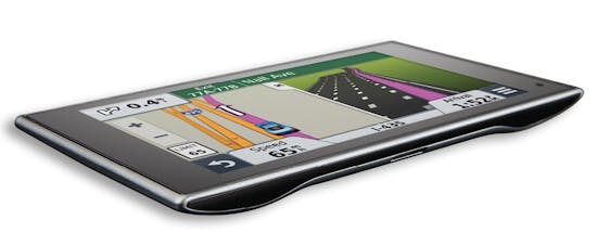
If you are willing to buy yet another gadget, a dedicated GPS device is one good choice. In a June poll, the mobile-tech site the Wirecutter found that most readers who bought such a device did so specifically because they worked in cellular dead zones. GPS devices use a receiver to pick up signals from a network of 24 satellites. It needs a minimum of three signals to triangulate your location. With more signals, it gets more accurate.
GPS devices have also gotten more useful, and cheaper. For instance, the Garmin Nuvi 2539LMT — Wirecutter's top pick this year — costs $200, is exceptionally easy to read and accurate, and includes additional information drivers will find useful: trip data, street names, points of interest, etc.
If two navigation devices are just one too many, you can add some Plan B backup right onto your smartphone.
Offline maps
Many leading navigation apps, like Waze, Apple Maps and Google Maps, let you (or even require you to) download maps for offline use. Most have significant drawbacks. Google Maps, for example, is limited in size and travel information, and the offline maps need a cell signal to do most key functions, such as searching, navigation and map layers. Google Maps limits you to six map downloads, after which you have to start paying.
Maps on GPS
Some navigation apps offer interfaces for offline maps and your phone's GPS system that allow for actual directions. Most have drawbacks. Here are two of the most popular apps.
Sygic GPS Navigation (sygic.com): The world map is $50 (but promotions are common). And though not entirely user-friendly, it will provide turn-by-turn directions. You can't ask for something generic like "hotels" — and you need to enter a physical address into a time-consuming format. Searching is slow, and routes may not be 100 percent reliable.
CoPilot (copilotgps.com/us/personal): A capable GPS-based app, it comes in basic (free) and premium formats. The basic doesn't come with much — you will have to pay $9.99 for turn-by-turn directions, for instance, ditto for live traffic information. The premium version costs $9.99 and comes with full navigation, including voice guidance and a one-year subscription to ActiveTraffic. Both versions come with one map (U.S., Europe, etc.); additional map downloads start at $24.99. Some reviewers say the search engine is clunky and slow, but the developers are continuously improving performance.
Crowdsourced navigation
While Waze is the world's largest community-based traffic and navigation app, it won't work without a cell signal. Enter OsmAnd (osmand.net), which may turn out to be the breakthrough app for navigation sans cell service. OsmAnd (it stands for OSM Automated Navigation Directions) is a map and navigation application with access to the free, worldwide and high-quality OpenStreetMap (OSM) data. All map data can be stored on your device's memory card for offline use. Then via your device's GPS, OsmAnd offers routing, with optical and voice guidance, for car, bike and pedestrian. All the main functionalities work both online and offline — no cell service required. OsmAnd+ is the paid version ($8).